
SPEAKING
resources to its staff, partners, and the community.
UPCOMING EVENTS
-
Oct 17th
Disruptions and Outages ( Work will occur on the exterior of the building. )
04:00 AM to 07:00 PM
Brackett Hall -
Oct 18th
Disruptions and Outages ( Work will occur on the exterior of the building. )
04:00 AM to 07:00 PM
Brackett Hall -
Oct 19th
Disruptions and Outages ( Work will occur on the exterior of the building. )
04:00 AM to 07:00 PM
Brackett Hall -
Oct 20th
Disruptions and Outages ( Work will occur on the exterior of the building. )
04:00 AM to 07:00 PM
Brackett Hall -
Oct 20th
Disruptions and Outages (Disruptions in the area of room 160 and room 161.  Contractors will be installing a new VAV box above the ceiling. )
12:00 PM to 09:00 PM
SC Water Resources Center
Staff Recognition


SAFETY FIRST
University Facilities helps provide a clean and welcoming campus for Clemson students, faculty, staff and visitors. Part of that responsibility includes encouraging a culture with an emphasis on safety. View Safety Program
View Safety ProgramExplore the Campus with GIS

The Base Map
The University Facilities Base Map contains assets, and infrastructure. Toggle various layers on and off, use markup tools, and export your annotations to a printable PDF.

Construction Map
The Construction Map is a publicly available resource describing impacts of active and planned projects to buildings, roads, and pedestrian pathways.
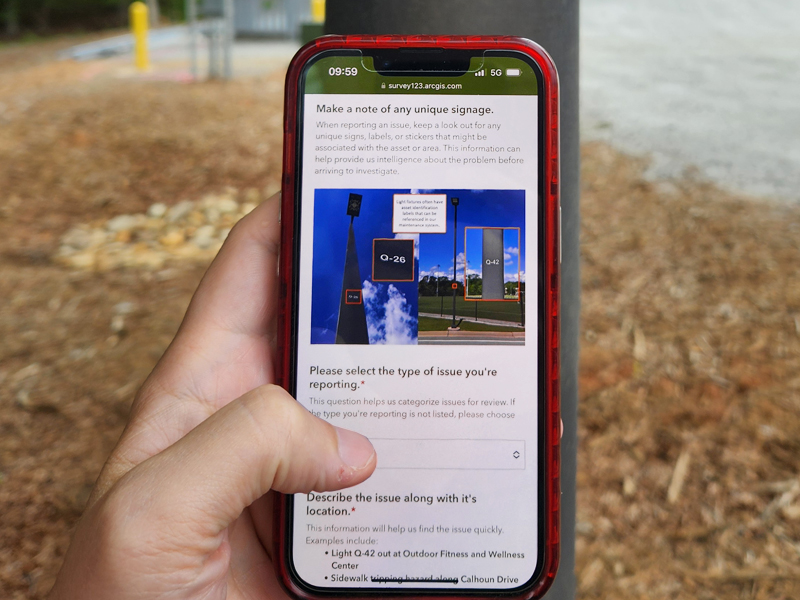
Campus Issue Reporter
The Campus Issue Reporter can be used by anyone--students, visitors, employees, or community members--to report outdoor infrastructure issues they notice around campus directly to University Facilities.
WE SERVE IN DEVELOPING AND MAINTAINING QUALITY LEARNING ENVIRONMENTS.
CONTINUOUSLY IMPROVE TO BECOME CLEMSON'S PREMIER SERVICE TEAM AND WORK ENVIRONMENT.
WE STRIVE FOR SAFETY, RESPECT, INCLUSION, DEVELOPMENT, STEWARDSHIP, AND PARTNERSHIP.